File:Northern icesheet hg.png
From Wikimedia Commons, the free media repository

Size of this preview: 800 × 587 pixels. Other resolutions: 320 × 235 pixels | 640 × 469 pixels | 1,024 × 751 pixels | 1,280 × 939 pixels.
Original file (2,236 × 1,640 pixels, file size: 305 KB, MIME type: image/png)
| Description |
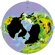
English: Northern hemisphere glaciation during the last ice ages. The accumulation of 3 to 4 km thick ice sheets caused a sea level lowering of about 120 m. Also, the Alps and the Himalayas were covered by glaciers. Winter sea ice coverage was much more limited in the south.
Español: Glaciación del hemisferio del norte durante el último periodo glaciar. La acumulación de 3-4 kilometros de hielo hizo descender el nivel del mar alrededor de 120 metros. También los Alpes y el Himalaya fueron cubiertos por glaciares. El hielo marítimo durante el invierno era más reducido en el sur. Italiano: Glaciazione dell'emisfero boreale durante l'ultima glaciazione. L'accumulo di strati di ghiaccio spessi da 3 a 4 km causò un abbassamento del livello del mare di circa 120 m e le Alpi e la catena dell'Himalaya erano coperti da ghiacciai. Durante l'inverno, i ghiacci sul mare erano molto più ridotti a sud.
Polski: Zlodowacenie półkuli północnej podczas maksimum ostatniego zlodowacenia. Utworzenie warstwy pokrywy śnieżnej o grubości od 3 do 4 km spowodowało globalne obniżenie poziomu mórz o około 120 m. Także Alpy i Himalaje zostały pokryte przez lodowce. W czasie zimy pokrycie morza lodem było znacznie ograniczone na południu.
Русский: Северное полушарие Земли во время последнего оледенения. Уровень Мирового океана упал на 120 м из-за расхода воды на 3–4-километровые ледники. Льдами были покрыты Альпы и Гималаи. Зимние льды в море простирались не столь далеко.
Українська: Північна півкуля Землі під час останнього заледеніння. Рівень Світового океану впав на 120 м через витрати води на 3–4-кілометрові льодовики. Льодом були вкриті Альпи та Гімалаї. Зимовий лід в морі простягався не дуже далеко.
|
| Date | |
| Source | own work - redrawn, supplemented and modified grafic from John S. Schlee (2000) Our changing continent, United States Geological Survey. |
| Author | Hannes Grobe/AWI |
| Permission (Reusing this file) |
Own work, attribution required (Creative Commons CC-BY-2.5) |
| Other versions |
in French : Image:Northern_icesheet-fr.png |
|
I, the copyright holder of this work, hereby publish it under the following license:
|
File history
Click on a date/time to view the file as it appeared at that time.
| Date/Time | Thumbnail | Dimensions | User | Comment | |
|---|---|---|---|---|---|
| current | 23:06, 21 July 2006 | | 2,236 × 1,640 (305 KB) | Hgrobe (talk | contribs) | {{Information| |Description= |Source=own work |Date=2000-04-07 |Author=~~~~ |Permission=Own work, share alike, attribution required (Creative Commons CC-BY-SA-2.5) |other_versions= }} {{self|cc-by-sa-2.5}} Category:Geology, Climate, Ice_Age, Arctic |
- You cannot overwrite this file.
File usage on Commons
The following 3 pages link to this file:
File usage on other wikis
The following other wikis use this file:
- Usage on af.wikipedia.org
- Usage on be.wikipedia.org
- Usage on bn.wikipedia.org
- Usage on cy.wikipedia.org
- Usage on da.wikipedia.org
- Usage on de.wikipedia.org
- Usage on en.wikipedia.org
- Ice age
- Talk:Pleistocene
- Quaternary glaciation
- Geology of Minnesota
- Glacial history of Minnesota
- Fauna of Europe
- User:Mporter/Climate data
- User:Kaarel/sandbox/Fauna of Europe
- Geology of the North Sea
- Geology of Saskatchewan
- User:Mark Buchanan/sandbox/QuatGlac
- User:Mark Buchanan/sandbox/Glaciation-WIP
- Usage on eo.wikipedia.org
- Usage on es.wikipedia.org
- Usage on fi.wikipedia.org
- Usage on fr.wikipedia.org
- Usage on hi.wikipedia.org
- Usage on hu.wikipedia.org
- Usage on it.wikipedia.org
- Usage on ka.wikipedia.org
- Usage on nl.wikipedia.org
- Usage on pa.wikipedia.org
- Usage on pl.wikipedia.org
- Usage on ru.wikipedia.org
- Usage on simple.wikipedia.org
- Usage on sk.wikipedia.org
- Usage on ta.wikipedia.org
- Usage on te.wikipedia.org
- Usage on tr.wikipedia.org
- Usage on uk.wikipedia.org
- Usage on zh.wikipedia.org