File:Northern icesheet-fr.png

Summary[edit]
| Description |
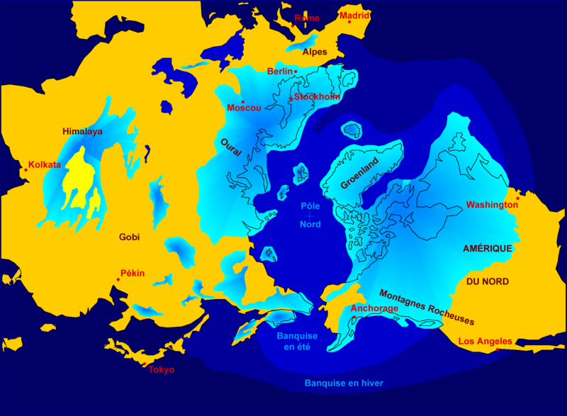
Northern hemisphere glaciation during the last ice ages. The set up of 3 to 4 km thick ice sheets caused a sea level lowering of about 120 m. Also the Alps and the Himalaya were covered by glaciers. The limit of winter sea ice coverage was much more to the south. |
| Date | 2000-04-07, modified October 2006 |
| Source | Image:Northern_icesheet_hg.png created by Hannes Grobe |
| Author | Hannes Grobe 23:06, 21 July 2006 (UTC), Alfred Wegener Institute for Polar and Marine Research, Bremerhaven, Germany, translated by Sting |
| Permission (Reusing this file) |
share alike, attribution required (Creative Commons CC-BY-SA-2.5) |
| Other versions |
in English : Image:Northern_icesheet_hg.png |
- Sujet : Carte de l'hémisphère nord durant la dernière glaciation. Une couche de glace de 3 à 4 km d'épaisseur a entraîné un abaissement du niveau de la mer d'environ 120 m. Les Alpes et l'Himalaya étaient recouverts par des glaciers. L'extension de la banquise en hiver allait bien plus au Sud qu'actuellement ;
- Source : Image:Northern_icesheet_hg.png créée par Hannes Grobe ;
- Auteur : Hannes Grobe, cette version par fr:Sting ;
- Date : Avril 2000, modifications : octobre 2006 ;
- Version originale anglophone : Image:Northern_icesheet_hg.png ;
- Version alternative : carte USGS (lien externe).

This map was improved or created by the Wikigraphists of the Graphic Lab (fr). You can propose images to clean up, improve, create or translate as well.
azərbaycanca · বাংলা · català · čeština · Deutsch · Deutsch (Sie-Form) · Ελληνικά · English · Esperanto · español · suomi · français · עברית · magyar · Հայերեն · italiano · 한국어 · македонски · Bahasa Melayu · Plattdüütsch · Nederlands · occitan · polski · português · română · русский · slovenščina · svenska · татарча/tatarça · Türkçe · українська · 中文 · 中文(简体) · 中文(繁體) · Zazaki +/−
Licensing[edit]
| This file is licensed under the Creative Commons Attribution-Share Alike 2.5 Generic license. | ||
|
File history
Click on a date/time to view the file as it appeared at that time.
| Date/Time | Thumbnail | Dimensions | User | Comment | |
|---|---|---|---|---|---|
| current | 19:16, 22 October 2006 |  | 2,236 × 1,640 (402 KB) | Sting (talk | contribs) | {{Information| |Description=Northern hemisphere glaciation during the last ice ages. The set up of 3 to 4 km thick ice sheets caused a sea level lowering of about 120 m. Also the Alps and the Himalya were covered by glaciers. The limit of winter sea ice c |
- You cannot overwrite this file.
File usage on Commons
The following page links to this file:
File usage on other wikis
The following other wikis use this file:
- Usage on de.wikipedia.org
- Usage on fr.wikipedia.org
- Pléistocène
- Glaciation
- Inlandsis
- Géographie de la Colombie-Britannique
- Histoire du monde
- Wikipédia:Atelier graphique/Images à améliorer/Archives/Novembre 2006
- Archipel finlandais
- Wikipédia:Sélection/Paléontologie (période géologique)
- Wikipédia:Lumière sur/Pléistocène
- Wikipédia:Oracle/semaine 48 2011
- Utilisateur:Orbitale/Brouillon Dernière période glaciaire
- Dernière période glaciaire
- Usage on gl.wikipedia.org