File:Last glacial vegetation map.png
This is a file from the Wikimedia Commons. Information from its description page there is shown below. Commons is a freely licensed media file repository. You can help. |
| Description |
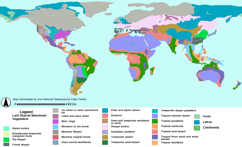
02:52, 5 May 2005 . . User:SEWilco (Talk | contribs) . . 782×549 (133,566 bytes) (Last Glacial Maximum Vegetation Reconstructed vegetation cover at the Last Glacial Maximum period ~18,000 years ago-( ~16th millennium BC), describing the type of vegetation cover present, based on fossil pollen samples recovered from lake and bog sediments. Derived from reconstructions by Jonathan Adams in the QEN Atlas, and Ray and Adams (2001).
Reconstructed vegetation cover at the Last Glacial Maximum period ~18,000 years ago, describing the type of vegetation cover present, based on fossil pollen samples recovered from lake and bog sediments. |
|||
| Date | ||||
| Source | http://map.ngdc.noaa.gov/website/paleo/paleoclimate/viewer.htm
Original source has moved. Image seems to be from data used for: |
|||
| Author | ||||
| Permission (Reusing this file) |
|
 |
This biogeographical map image could be recreated using vector graphics as an SVG file. This has several advantages; see Commons:Media for cleanup for more information. If an SVG form of this image is available, please upload it and replace afterwards this template with {{vector version available|new image name.svg}} or just {{NowSVG}}. |
File history
Click on a date/time to view the file as it appeared at that time.
| Date/Time | Thumbnail | Dimensions | User | Comment | |
|---|---|---|---|---|---|
| current | 22:56, 26 November 2007 | | 782 × 477 (87 KB) | Jrockley | cleaner |
| 02:29, 16 December 2006 | 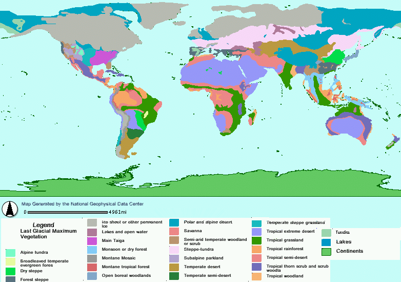 | 782 × 549 (130 KB) | Fabartus | ;Below is xfer upload using w:Image:Last glacial vegetation map.png as source. ;Last Glacial Maximum Vegetation Reconstructed vegetation cover at the Last Glacial Maximum period ~18,000 years ago, describing the type of vegetation cover present, bas |
File usage
Global file usage
The following other wikis use this file:
- Usage on ca.wikipedia.org
- Usage on da.wikipedia.org
- Usage on de.wikipedia.org
- Usage on es.wikipedia.org
- Usage on fr.wikipedia.org
- Usage on ga.wikipedia.org
- Usage on it.wikipedia.org
- Usage on ja.wikipedia.org
- Usage on la.wikipedia.org
- Usage on nl.wikipedia.org
- Usage on nn.wikipedia.org
- Usage on no.wikipedia.org
- Usage on ru.wikipedia.org
- Usage on sv.wikipedia.org
- Usage on tr.wikipedia.org
- Usage on uk.wikipedia.org
- Usage on zh.wikipedia.org