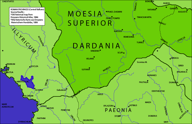
File:RomanDardaniaMoesiaSuperior1.png
From Wikimedia Commons, the free media repository

Size of this preview: 800 × 518 pixels. Other resolutions: 320 × 207 pixels | 640 × 415 pixels.
Original file (886 × 574 pixels, file size: 134 KB, MIME type: image/png)
| Description |
Dardania inside the Roman province of Moesia Superior,Recreated from part of Old historical map from Droysens Historical Atlas, 1886 |
||
| Date | |||
| Source | Gustav Droysens Allgemeiner historischer Handatlas in 96 Karten mit erläuterndem Text Bielefeld [u.a.]: Velhagen & Klasing 1886, S. 16. | ||
| Author | User:Megistias | ||
| Permission (Reusing this file) |
|
||
| Other versions | This file derives from |
File history
Click on a date/time to view the file as it appeared at that time.
| Date/Time | Thumbnail | Dimensions | User | Comment | |
|---|---|---|---|---|---|
| current | 15:01, 16 February 2010 |  | 886 × 574 (134 KB) | Megistias (talk | contribs) | {{Information |Description=Dardania inside the Roman province of Moesia Superior,Recreated from part of Old historical map from Droysens Historical Atlas, 1886 |Source=Gustav Droysens Allgemeiner historischer Handatlas in 96 Karten mit erläuterndem Text |
- You cannot overwrite this file.
File usage on Commons
The following 6 pages link to this file:
- Ancient Thrace and Ancient Thracians
- Atlas of the antiquity
- Illyria and Illyrians
- File:Late roman province Thracia Outcut from Roman provinces of Illyricum, Macedonia, Dacia, Moesia, Pannonia and Thracia.jpg
- File:Roman provinces of Illyricum, Macedonia, Dacia, Moesia, Pannonia and Thracia.jpg
- File:Thracia Outcut from Roman provinces of Illyricum, Macedonia, Dacia, Moesia, Pannonia and Thracia.jpg
File usage on other wikis
The following other wikis use this file:
- Usage on en.wikipedia.org
- Usage on mk.wikipedia.org
- Usage on sr.wikipedia.org
- Usage on tr.wikipedia.org
- Usage on www.wikidata.org
