File:Pannonia02-sr.png
From Wikimedia Commons, the free media repository

Size of this preview: 668 × 599 pixels. Other resolutions: 268 × 240 pixels | 535 × 480 pixels | 669 × 600 pixels.
Original file (1,001 × 898 pixels, file size: 75 KB, MIME type: image/png)
Summary[edit]
| Description |
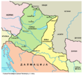
English: Historic map - Roman provinces Pannonia Superior and Pannonia Inferior in the 2nd century.
Српски / srpski: Историјска карта - Римске провинције Горња Панонија и Доња Панонија у 2. веку.
|
| Date | |
| Source | Own work |
| Author | PANONIAN |
Licensing[edit]
|
I, the copyright holder of this work, hereby publish it under the following license:
|
References[edit]
- Dragan Brujić, Vodič kroz Svet antike, Beograd, 2005.
- Denis Šehić - Demir Šehić, Istorijski atlas Sveta, Beograd, 2007.
- The Times History of Europe, Times Books, London, 2002.
- Istorijski atlas, Geokarta, Beograd, 1999.
- Školski istorijski atlas, Zavod za izdavanje udžbenika SR Srbije, Beograd, 1970.
- The Times Atlas Svjetske Povijesti, Cankarjeva založba, Ljubljana - Zagreb, 1986.
- http://ebedszu.net/zsolt/terkep/pannonia_nagy.jpg
- File:Roman provinces of Illyricum, Macedonia, Dacia, Moesia, Pannonia and Thracia.jpg
- File:Roman provinces in a 1867 school atlas.jpg
File history
Click on a date/time to view the file as it appeared at that time.
| Date/Time | Thumbnail | Dimensions | User | Comment | |
|---|---|---|---|---|---|
| current | 10:45, 6 June 2014 |  | 1,001 × 898 (75 KB) | PANONIAN (talk | contribs) | changed some names |
| 12:10, 7 January 2014 |  | 1,001 × 898 (75 KB) | PANONIAN (talk | contribs) | {{Information |Description ={{en|1=Historic map - Roman provinces Pannonia Superior and Pannonia Inferior in the 2nd century.}} |Source ={{own}} |Author =PANONIAN |Date =2014 |Permission = |other_versi... |
- You cannot overwrite this file.
File usage on Commons
There are no pages that link to this file.
File usage on other wikis
The following other wikis use this file:
- Usage on sr.wikipedia.org