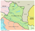
File:Pannonia01b.png
From Wikimedia Commons, the free media repository

Size of this preview: 668 × 599 pixels. Other resolutions: 268 × 240 pixels | 535 × 480 pixels | 669 × 600 pixels.
Original file (1,001 × 898 pixels, file size: 71 KB, MIME type: image/png)
Summary[edit]
| Description |
English: Historic map - Roman Pannonia in the 1st century (version without Emona).
Српски / srpski: Istorijska karta - Rimska Panonija u 1. veku (verzija bez Emone).
|
| Date | |
| Source | Own work |
| Author | PANONIAN |
Licensing[edit]
|
I, the copyright holder of this work, hereby publish it under the following license:
|
References[edit]
- Dragan Brujić, Vodič kroz Svet antike, Beograd, 2005.
- Školski istorijski atlas, Zavod za izdavanje udžbenika SR Srbije, Beograd, 1970.
- http://www.hipkiss.org/data/maps/j-m-dent-and-sons_atlas-of-ancient-and-classical-geography_1912_vindelicia-rhaetia-noricum-pannonia-illyricim-austria-hungry-balkans_2599_2067_600.jpg
- http://www.emersonkent.com/images/maps/thrace_map.jpg
- http://www.miklianmaps.com/images/1879%20ginn%20heath%2009%20pannonia.jpg
- File:Roman provinces of Illyricum, Macedonia, Moesia, Pannonia and Thracia.jpg
- File:Roman provinces in a 1867 school atlas.jpg
Additional references according to which Emona was not in Pannonia:
File history
Click on a date/time to view the file as it appeared at that time.
| Date/Time | Thumbnail | Dimensions | User | Comment | |
|---|---|---|---|---|---|
| current | 11:50, 6 June 2014 |  | 1,001 × 898 (71 KB) | PANONIAN (talk | contribs) | {{Information |Description ={{en|1=Historic map - Roman Pannonia in the 1st century (version without Emona).}} |Source ={{own}} |Author =PANONIAN |Date =2014 |Permission = |other_versions = }} |
- You cannot overwrite this file.
File usage on Commons
The following 3 pages link to this file: